St Cybi’s church stands within the precincts of Caer Gybi Roman Fort.
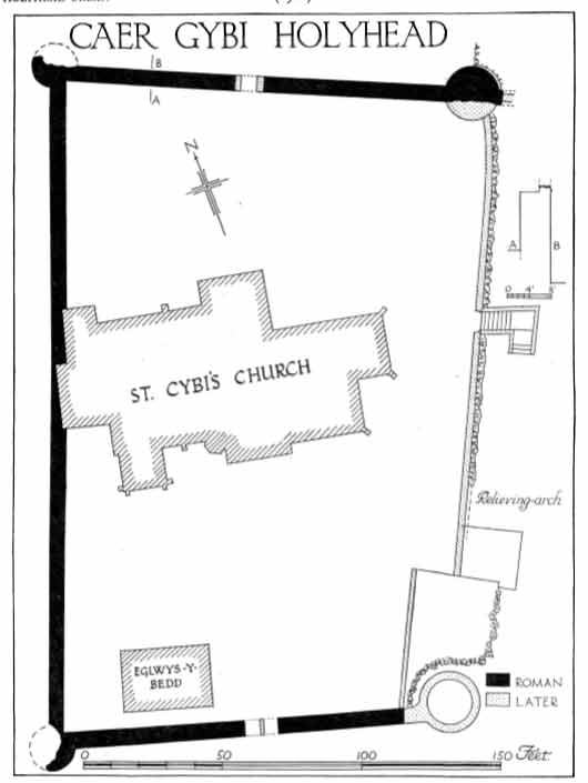
A plan of the Roman Fort as shown in the Royal Commission’s 1937 Inventory of Anglesey.
As a near complete structure Caer Gybi Roman fort is important. It is unique in that no other example of a three-sided landing place is known in Britain, and is one of only a small number of such forts still existing in Europe. The level of preservation means that it ranks highly alongside examples that include sites in Germany and Hungary. As such, this aspect of the fort’s value imparts a degree of international significance.
The existing remains are all at cliff top level, but it is thought the north and south walls originally extended down to sea level, giving a secure area for loading and unloading ships. The Survey and Inventory of Anglesey by the Royal Commission on Ancient and Historical Monuments in Wales and Monmouthshire, published in 1937 says the projecting spurs of these extensions were blasted away when the lower churchyard was made early in the 19thcentury. Evidence of a wall continuing beyond the tower in the north east corner of the fort is still visible.
Whilst the external walls of the fort remain largely intact, we have no evidence of what buildings there were within the fort. There would have been a need for administrative quarters; barracks for officers and men; latrines; kitchen; facilities for storage of food and equipment and, possibly, stabling for a few horses. These structures may well have been made of timber. Centuries of use as a burial ground means it is almost certain any evidence of timber structures will have been destroyed long ago.
Not far from the fort, at the summit of Holyhead Mountain is Caer y Twr, where there was a Roman watchtower which has been linked to the fort. This is thought to have been a lookout post to warn of anyone approaching by sea.
Cadw’s Scheduled Monument listing (AN031) describes Caer Gybi fort:
The monument consists of the remains of a Roman fort. It is sub-rectangular and measures approximately 75m by 45m. The interior is occupied by St Cybi’s church and associated graveyard. The fort lies on a low cliff which would originally have fronted the shore; the east side of the fort which faces the shore is open and there is evidence to show that the north and south walls once continued east towards the water’s edge. The remaining part of the fort on top of the cliff occupies 0.32ha; the walls are about 4m high and 1.5m thick.
The north wall is the best preserved and shows details of a rampart walk and parapet, the former being about 1m wide. Two rows of putlog holes are also visible, the upper row being 1.5m above the lower. A narrow entrance in the centre of this wall is probably a late insertion.
A car park occupies the area outside the north wall.
The church tower is built against the west wall on the inside of the fort, whereas on the outside the south part has been built against and the north part is free-standing. The south wall is also largely built against, but in the centre there is a fine double arched entrance which, although rebuilt, is probably original.
There was originally a tower at each of the four corners. The south west tower is mostly destroyed and hidden by modern buildings. The north east and south east towers have been largely rebuilt in late medieval or modern times, though they are Roman at the base. The north west tower survives in its original form. The foundations of the north east tower start at the base of the cliff and the remains of a wall running east are bonded into this tower.
The east side is a fairly level cliff face supplemented with a stone retaining wall, which contains a relieving arch at the south end. A modern churchyard wall stands on top of the cliff.
The position of this site on a low sea-side cliff, together with the suggestion of an enclosed quay, and its similarity with Roman coastal forts in general, have given rise to its interpretation as a late Roman coastal fort. Although there is no direct dating evidence from the site, indications from recent excavations on Roman forts elsewhere in Wales – notably at Cardiff, Loughor and Neath – have demonstrated a definite pattern of late third-century coastal defence. Caer Gybi may well have been part of such a consolidated network, defending the Welsh coast from Irish raiders. It may have been linked with the late Roman watchtower of Caer y Twr, and a possible second example on Carmel Head. The monument is of national importance for its potential to enhance our knowledge of Roman military organisation. The monument forms an important element within the wider context of the Roman occupation of Wales and the structures may contain well preserved archaeological evidence concerning chronology, layout and building techniques. The scheduled area comprises the remains described and areas around them within which related evidence may be expected to survive.
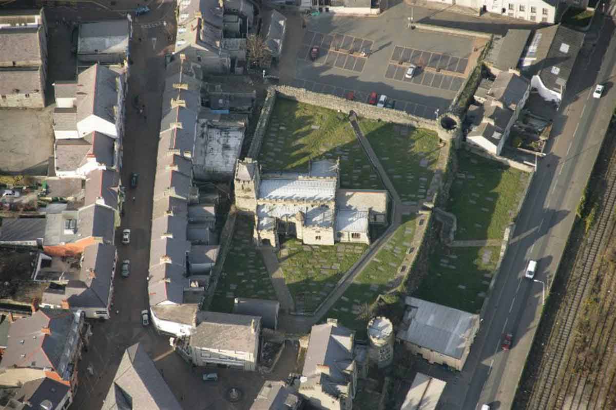
 An aerial view of the Roman Fort and St Cybi’s church. The entrance between the buildings on the south side is modern, but this is where the original entrance was. The access to the car park on the north side is modern. Originally there would have been no entrance on this side of the fort. (photo copyright Royal Commission on the Ancient and Historical Monuments of Wales).
The picture also shows how, before the introduction of strict planning laws in the 20thcentury adjoining properties, including the church, were able to build against, and on, the walls of the fort.
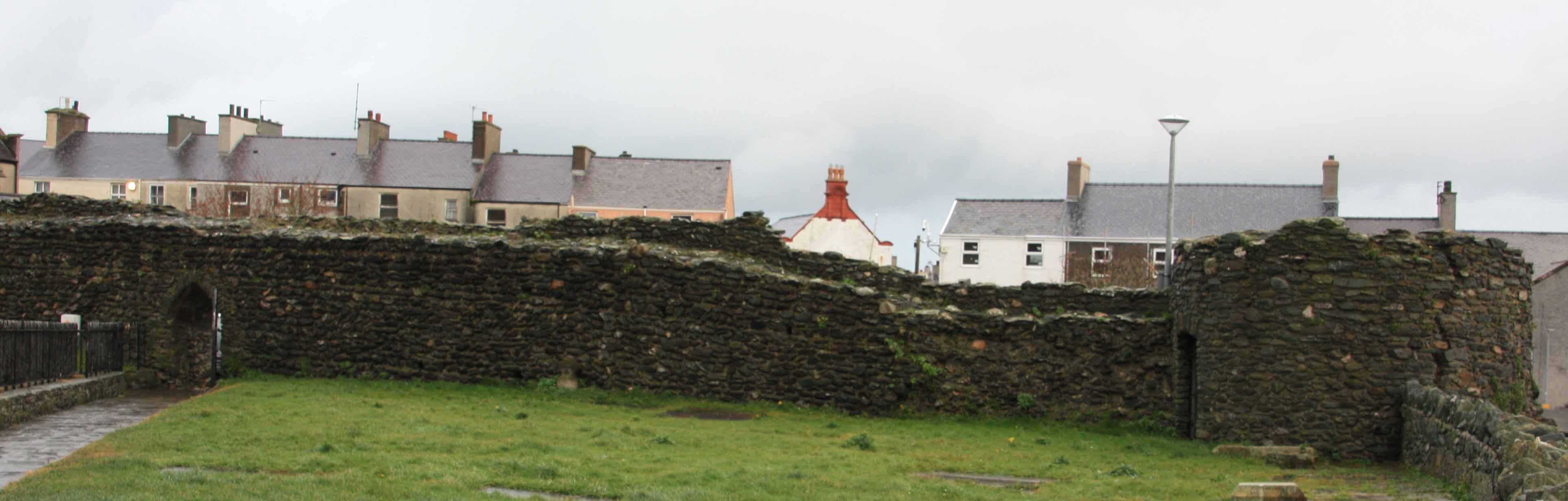
A section of the north wall of the fort, showing the modern gateway leading to the Swift Square car park on the other side of the wall, and the circular tower in the north east corner of the fort. Whilst a large part of the remnants of this tower are Roman, there have been some modern repairs to the tower. The low wall on the right of the picture runs along the top of the cliff and is a modern retaining wall. The low wall on the right of the picture runs along the top of the cliff and is a modern retaining wall.
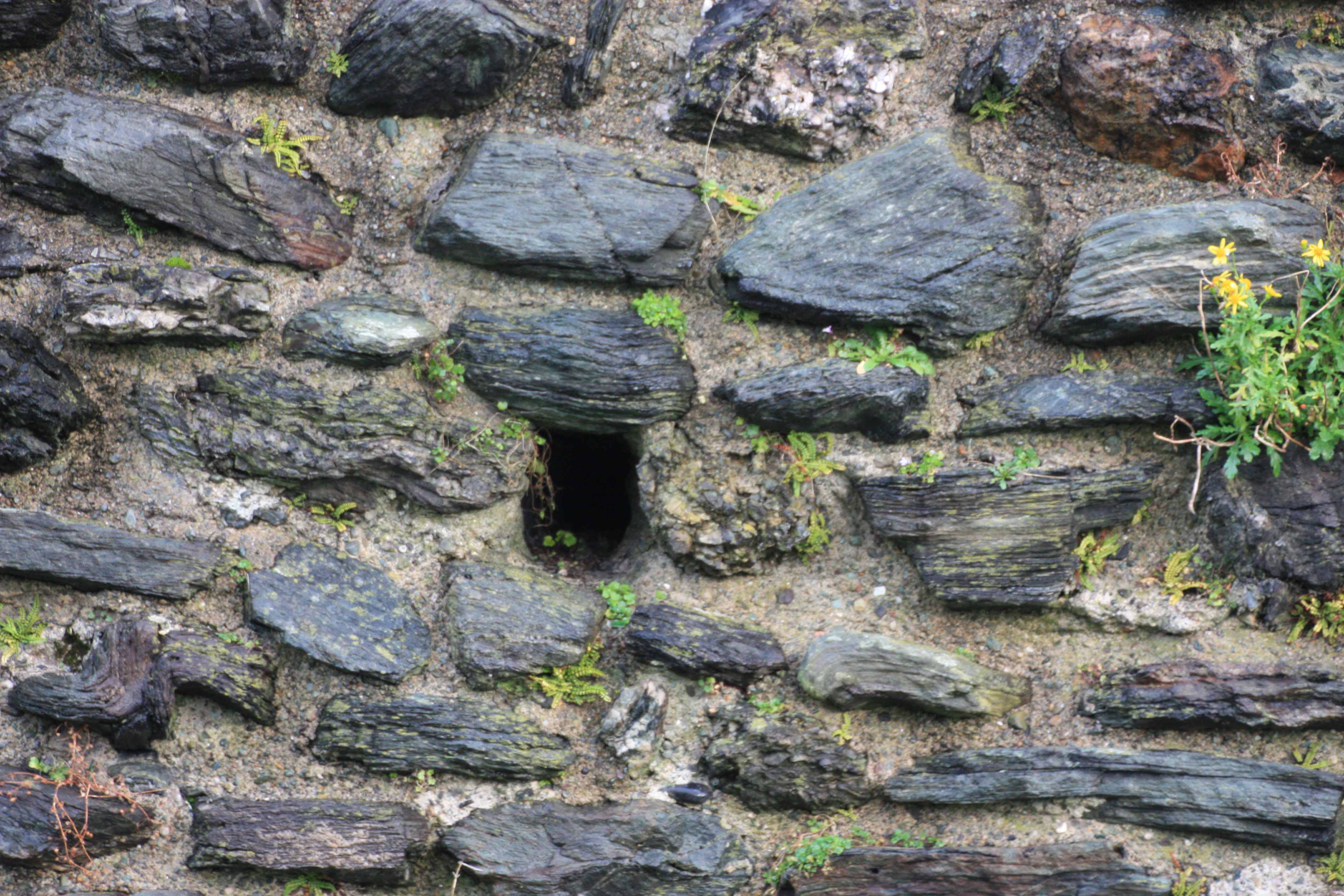
The original putlog holes can still be seen. These would have been used to support wooden scaffolding used during the construction of the wall.
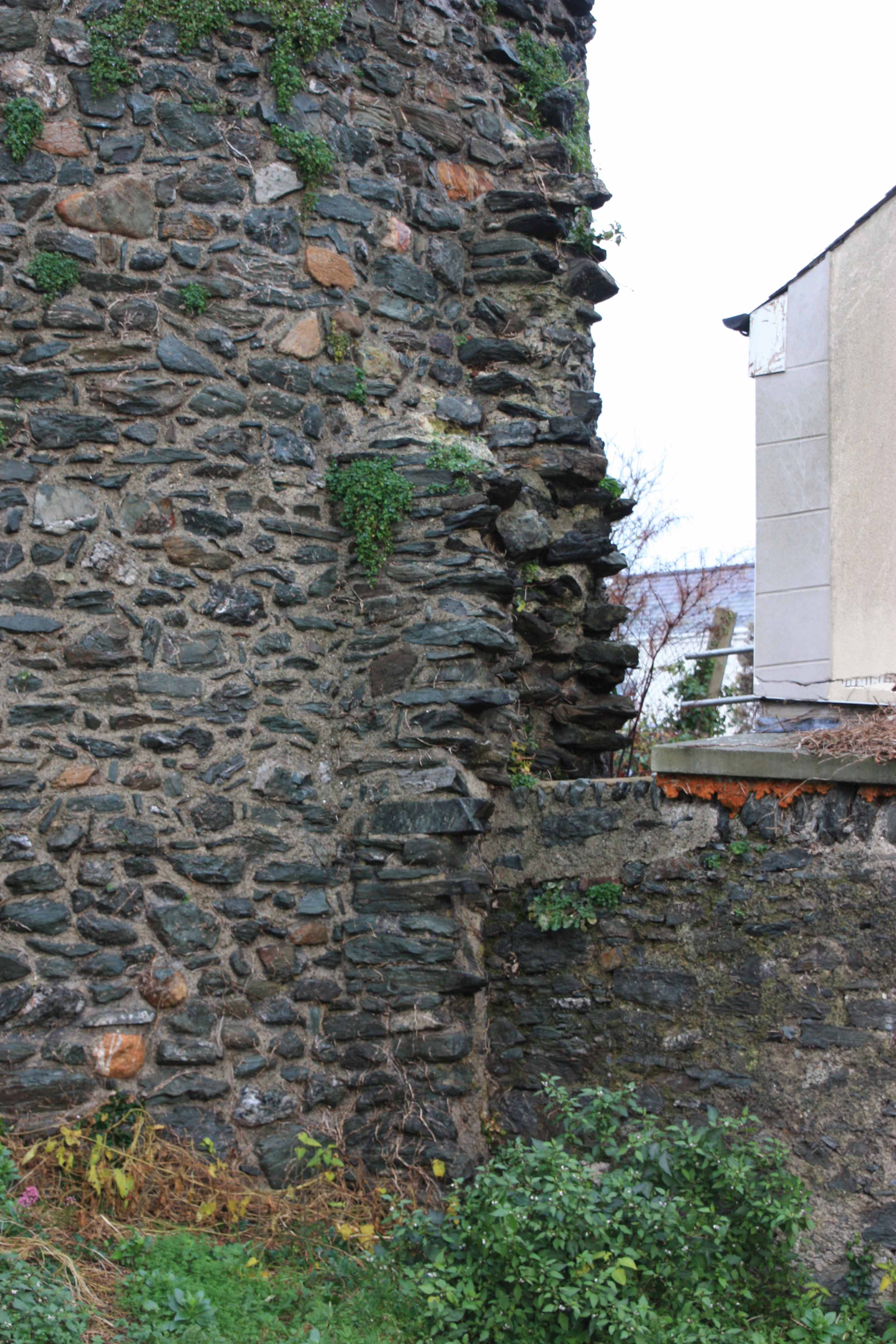 Until the 1800s the sea came up to the base of the cliff. It is believed that during the Roman occupation the walls of the fort extended past the towers which can be seen in the aerial photograph down to the shoreline, where boats would have been beached for loading and unloading. This photograph of the base of the north east tower shows evidence of this continuation of the wall.
These extensions to the wall would have given the boats some protection against attack.
The low wall on the right of the photograph is the modern boundary wall of the lower churchyard.